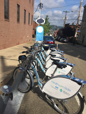
Oh, and one of the most important details - the challenge is called Cycle to the Moon because all who complete the challenge will have their name and photo literally sent to the moon in the Pittsburgh Bicentennial time capsule! How cool is that? I'm still holding out hope that my person will have the chance to travel to the moon one day, but having my name and likeness there is a good place to start.
Riders could visit stations in any order, and I chose to start at 42nd and Penn in Upper Lawrenceville next to the Children's Hospital. That station is just a couple blocks walk from my husband's work, so it was convenient to ride in with him. Added bonus: it's at the top of a giant, steep hill from the next closest stop, so it meant I could strategically cut a climb out of my ride by starting there!
As always, one of my favorite things about events like this is getting to explore my city. As it turns out, I did a bit more "exploring" than intended in East Liberty as I took a couple of wrong turns, and also missed a couple stations and had to double back on myself. Oops! East Liberty used to be one of my stomping grounds when I was a Pitt student, but it turns out that I don't remember all it's nooks and crannies, especially with so many new additions in the area like Bakery Square and the Ace Hotel. The cool thing about being lost, though, is getting to see all of these beautiful new parts of Pittsburgh up close and personal.
I made about 10 wrong turns cutting up from East Liberty to find the station at Penn and N Fairmount, which is especially funny to me since it's about half a mile down the road from where I started.
Fortunately, by the time I made it to Walnut Street in Shadyside, I was back in familiar territory, and knew I would be for the rest of the ride. I even stopped to rest and drink some water across from one of my most familiar places - the Apple Store!
By the time I made it to Oakland, I was ready for some lunch. The East End of the course had provided only mild hills, and very cool temperatures in the morning hours, but I had been at it long enough that I was not only hungry, but also craving some time in the air conditioning! I decided to dock my bike at Frew Street and Schenley Drive station and head to Phipps Conservatory for a bite to eat.
Phipps, in addition to being a beautiful place to view flowers, trees, and other plants, has a pretty delightful cafe with lots of light, healthy fare. I lunched on a turkey and siracha berry jam panini with brussels sprout slaw. Yum, yum, yum!
Lunch had me reinvigorated and ready to tackle the remainder of the course. From Oakland, I decided to head to the South Side, and coasted down the steep hill of Bates Street towards the Hot Metal Bridge, ready to cross another of Pittsburgh's beautiful rivers in search of the next few stations.
The South Side is always a pleasant ride. Carson Street and its parallels are straight and flat. In fact, this stretch of Carson Street boasts itself as the flattest mile on course during the Pittsburgh marathon. There were 5 Healthy Ride stations in the South Side, all roughly along the main drag of Carson. The South Side, just like East Liberty, Shadyside, and Oakland before it, also supports cyclists with plentiful bike lanes and signage reminding motorists to "share the road."
From the South Side, I took the 10th Street Bridge back over the Monongahela, and prepared to visit the Downtown stations. At the end of the bridge, I used the Armstrong Tunnel to cut under the hill housing Duquesne University. I have no idea whether bikes are allowed to ride on the street in the tunnel, but it seemed like a bad idea so I dismounted and walked it on the sidewalk. Among the many strange mysteries of Pittsburgh, Armstrong is about the only tunnel I know to feature a pedestrian sidewalk.
I stopped to consult the map on my phone after leaving the tunnel. All I had left to visit were the stations in Downtown, the North Side, the Strip, and Lower Lawrenceville, right? WRONG. I made a glaring omission by trying to forge my own course. I had forgotten that there is one, lone station in the Hill District, and the very tip top of Center Avenue. I was going to have to climb about 250 feet up from Consol Energy Center to make my one missing stop at Center and Kirkpatrick.
I was absolutely exhausted after climbing up into the aptly-named Hill District, however, I was happy to remember that what goes up must come down! Flying back down the hill towards town certainly felt refreshing and well-deserved!
After my almost-omission of the Hill, I was happy to find that visiting the Downtown stations was almost completely unceremonious. Nothing crazy happened. None got lost along the way. No news felt like good news. At this point, I had 40 stations down, and 10 to go. 4 in the North Side, 4 in the Strip District, and 2 in Lower Lawrenceville.
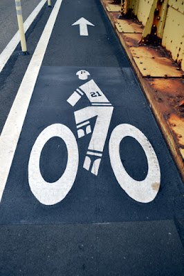
The 4 North Side stations are kinda out on their own little island compared to the rest of the Healthy Ride locations, but I am always happy to cross the Allegheny towards one of my favorite city neighborhoods, especially on the all-time coolest bike lane on by all-time favorite bridge. The Roberto Clemente (6th Street) Bridge celebrates biking as well as the Pirates' all-time great outfielder with these awesome graphics of Roberto biking while dressed in his uniform.
Visiting the North Side stations also proved uneventful as I cycled past two adjacent to PNC park then made the mild climb up to stations near CCAC and the Mexican War Streets. I crossed back over Clemente, this time serving as the final bridge on my course, and counted down just as I do at the end of a long run. 44 down, 6 to go.
The straightaway of Penn and Butler in the Strip District and Lawrenceville served as the final portion of my course. These sections of town are typically easy to ride, though I realized as I entered the busiest area of the Strip that I was going the wrong way! The Healthy Ride Stations were located along Penn Ave, however, the flow of Traffic on Penn is inbound only, and I was going the opposite way. Let's just say I was a little creative with how I rode through this neighborhood, sometimes on the sidewalk, sometimes on the street, and sometimes dismounted and pushing the bike. Kids, probably don't try this at home.
Finally, I made it to the Doughboy statue and bared left on Butler Street (yes, with the proper flow of traffic now) to visit the final two stations at 37th and 42nd Streets.
Finally! Locked my bike at the Butler and 42nd Street station, took a big swig of water, and cheesed for the camera. I'm going to the moon!
I so enjoyed this challenge and many thanks to the folks at Healthy Ride for designing it! The feeling of pride accomplishing something like this, and the unique way to enjoy my city are two of the main reasons I run, hike, and ride! And, well, the fact that I can say that my photo will be on the moon is just the icing on the cake. Hopefully I will find something similarly fun during next year's bike fest. Until then, ride, yinzers, ride!


